Tuesday, January 29, 2013

1/28 – Moorea & 1/29 – Bora Bora, Society Islands, French Polynesia

Moorea is one of the South Pacific islands that is part of the Society Islands, one of the five major island groups that form French Polynesia.  The island of Moorea is administratively part of the municipality of Moorea-Maiao, which itself is in the administrative subdivision of the Windward Islands.  The island was formed as a volcano approximately 1.5 to 2.5 million years ago, the result of a geologic hotspot in the mantle under the oceanic plate that formed the whole of the Society Archipelago.¹

Bora Bora is an island in the Leeward group of the Society Islands of French Polynesia, an overseas territory of France in the Pacific Ocean.  The island was settled by Tongan people about the 4th century.  Bora Bora’s main attraction is its calm and crystal clear lagoon offering the full array of nautical and land activities.  The waters are said to be some of the most beautiful in the world.

Both of these islands were lovely.  We enjoyed walking the beach and adding to our sand collection.  :-)

Moorea - View from our verandah

Moorea - Greeting band

Moorea - Canoe on beach

Bora Bora - Rainbow

Bora Bora - ms Amsterdam from shore

Bora Bora - Reef
¹Holland America Explorer

Sunday, January 27, 2013

01/27 – Papeete, Tahiti, Society Islands, French Polynesia

Papeete (meaning “water from a basket”) is the capital of French Polynesia located on the island of Tahiti, in the administrative subdivision of the Windward Islands.  It is the primary center of Tahitian and French Polynesian public and private governmental, commercial, industrial and financial services, the hub of French Polynesian tourism and a commonly used port of call for tourism.¹
We didn’t do much here, just wandered around the little town, browsed the open air market and did a lot of people watching.
View from our verandah

Greeting Band


Kayaks on beach

Open air market

View from our verandah


Open air market

¹ Holland America Explorer


Monday, January 21, 2013

1/21 – Easter Island, Chile

Easter Island, known in the native language as Rapa Nui (Big Rapa) or Isla de Pascua in Spanish, is an island in the south Pacific Ocean belonging to Chile (a province unto itself of the Chilean Valparafso Region). Located 2237 miles (3600 km) west of Chile and 1290 miles (2075 km) east of Pitcairn Island, it is one of the most isolated inhabited islands in the world. It was given its common name of “Easter” because it was discovered by the Dutch on Easter Sunday, 1722.

The island is 45 sq-mi (117 sq-km) and there are nearly 3,000 residents, many of them working in military or government service. Ancient volcanoes spawned the triangular island, and remnants of them can be found at each corner. All are extinct, but a series of unexplored lava caves and tubes leaves no doubt they were once active.¹

Moai remain the central focus of scientific research on the island, so of course we had to see them! There are about 600 moai that have been resurrected. All have similar features. The significance of the face and deep-set eyes will probably never be known. Almost all moai have been carved from soft volcanic rock (basalt) at Rano Raraku quarry, transported several miles and then stood upright. There are many theories on how that was accomplished by people with no modern equipment. All are enormous, many more than 18 ft (5.5 m) tall and weighing several tons. Deceased ancestors were usually buried in subterranean vaults below the statues. They were truly fascinating to see!
Tender Ride

Rodney @ Moai Statues in Hanga Roa

Moai Statue @ Hanga Roa

Moai Statues @ Rano Raraku Quarry

Sheryl @ Tongariki Platform

15 Moai Statues @ Tongariki Platform
¹ Holland America Explorer and Port at a Glance

Wednesday, January 16, 2013

1/16 – Lima, Peru

Lima is the capital and largest city in Peru, as well as the capital of Lima Province.  It is the cultural, industrial, financial, and transport hub of the country.  The city is located in an area encompassing the valleys of the Chillon, Rimac, and Lurin rivers, laying on a deserted coast adjacent to the bay in the Pacific Ocean.  Founded by Spanish conquistador Francisco Pizarro in 1535, Lima is also known as the “City of Kings.”¹

We didn’t see much of Lima, just a bus tour as we made our way back to the ship from Cusco.

¹Holland America Explorer
City Tour Building

City Tour Building

Add caption

War Memorial

City Tour Building

Houses on hillside

Tuesday, January 15, 2013

1/15 – Machu Picchu, Peru

Our trip to Machu Picchu began with a train ride aboard the Hiram Bingham Railway where we were welcomed with champagne, music and dancers. We enjoyed a very pleasant three hour ride aboard their very elegant train. They served us a delicious four course brunch and enjoyed one of their local bands in the “bar car” for awhile. What a way to travel!

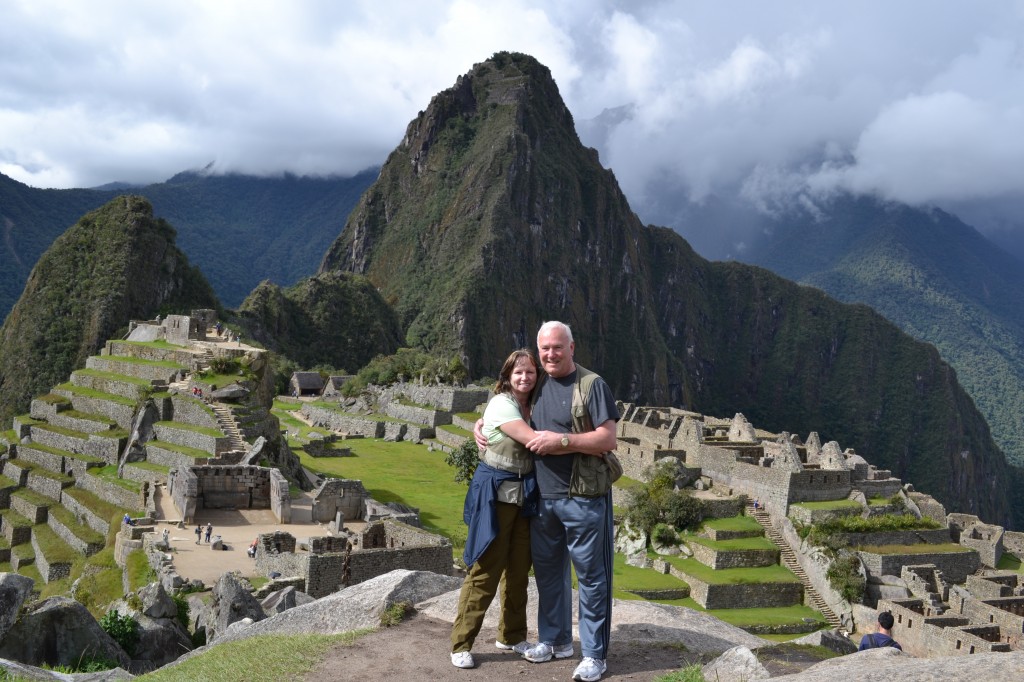
There are no words to describe Machu Picchu—the Lost City of the Incas. It truly took my breath away and brought tears to my eyes. This stone city was constructed by incredibly sophisticated techniques with huge blocks of stone fitted together perfectly—an example of precision that is elusive event with laser technology used today. I was amazed at how large the city really is!


Us @ Machu Picchu

Monday, January 14, 2013

1/14-16 - Cusco, Peru

Our ship docked at the port in Calleo, Peru. From there, we were transferred to the airport for our flight to Cusco, located at an elevation of 11,152 feet above sea level. Needless to say, the altitude change took some getting used to. They encourage you to drink the Coca tea (yes, made from Coca, aka cocaine, leaves, though not strong enough to hurt anyone) and lots of water to help avoid altitude sickness. We took their advice and seemed to deal with it just fine, though others on our tour were not so lucky. Rodney did have some trouble sleeping and catching his breath at night, but otherwise it didn't really bother us.

Our hotel was a 5-star hotel located in Cusco named the Hotel Monasterio and it was absolutely gorgeous! It's an old monastery now remodeled into a hotel. The bed alone was half the size of our entire room on the ship! We had breakfast and lunch in the hotel restaurant and it was delicious. Dinner the first night was in a restaurant near the hotel called the Map Cafe. We were served multiple courses, but the main course was lamb medallions and it was absolutely the best lamb I have ever eaten. Part of the dessert was a liquor served in a glass that was actually edible - they broke it on the plate after it was served. It was some sort of frozen candy.

We visited some Incan ruins called Saqsaywaman while in Cusco. The area wasn't nearly as big as Machu Picchu, but still very interesting. As you can see from the photos, some of the boulders they used were much larger than in Machu Picchu. Evidently, the rock quarry they came from was over 5 miles away. Amazing to think of how they were able to move those big rocks and fit them together the way they did!

Grounds at Hotel Monasterio
 
Saqsaywaman Incan Ruins


Sheryl @ Saqsaywaman

Saqsaywaman Incan Ruins

Lounge at Hotel Monasterio

Rodney relaxing @ Hotel Monasterio

Friday, January 11, 2013

1/11 - Manta (Quito), Equador

The city of Manta has existed since pre-Columbian times and is located in Manabi Province, Ecuador. Once a small trading post for the Mantas and the Incans, it has grown in the last 50 years to over 200,000 inhabitants with a booming economy in tuna fishing, tourism, and chemical products ranging from cleaning supplies to oils and margarine. Manta is also known throughout Ecuador for its superb seafood and unique variations of preparations.¹

Didn’t do a lot here, mostly watched the tuna fisherman unloading their boat. We were here for over 10 hours and they never stopped unloading from the same boat. It was like it had an endless bottom!

¹ Holland America Explorer
Rodney on our verandah

Water fountain in the town square

Tuna boats

Tuna catch

Tuna catch

Tuna truck

Wednesday, January 9, 2013

1/9 - Panama Canal

The Panama Canal, a masterpiece of engineering, is considered to be the Eighth Wonder of the Modern World and has shortened the trip around the continent of South America by 7,000 miles (11,265 kilometers). The Canal itself was first perceived by King Charles V of Spain, who, in 1523, prompted by Balboa and Cortez, decided to make a survey of the Canal area. The survey was completed in 1524, but the enormity of the task disillusioned the Spanish and discouraged any attempts at construction. In 1894, the Gold Rush brought about both the completion of the Panama Railroad across the Isthmus and the development of the West Coast of the United States. After Panama’s independence from Colombia in 1903, Panama and the United States signed a treaty authorizing the construction of the Panama Canal. The United States guaranteed Panama’s independence and, for the sum of $10,000,000, Panama granted the United States power and authority within the then ‘Canal Zone.’ In addition, the United States agreed to pay an annuity of $250,000 beginning nine years after the ratification of the treaty. This annuity was increased to $430,000 in 1936 and to $1,930,000 in 1955. On May 4, 1904, the United States purchased the rights and properties of the Canal construction from the French Canal Company for $40,000,000. Ten years later, after the loss of over 6,000 lives from Yellow Fever and Cholera, the Panama Canal was completed at a cost of $387,000,000. In 1999, the government of Panama was granted full authority of the enterprise.¹

This was the second time we have made the transit through the Panama Canal, but it was just as exciting. It took us approximately 10 hours to make the transit all the way through the canal.

¹ Holland America Explorer
Gaton Locks

Rodney on deck
View from our verandah
Entering Pedro Miguel Locks
Ship next to us in Pedro Miguel Locks
Pedro Miguel Locks Train
Centennial Bridge
Canal Expansion Project